|
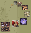
The Plant Distribution Mapper plots known locations of plants on a map of
South Australia from herbarium collections held by the State Herbarium of
South Australia. To plot
herbarium specimens from all Australian herbaria
on a map of Australia see Australia's Virtual Herbarium.
Current Coverage
Map coverage provided is for the whole of South Australia
and includes the ability to plot the distribution in relation to major
roads, towns, National Parks and environmental regions.
Locations are provided to multiples of 10 minutes latitude and longitude and each
of the dots can be interrogated for further information about the
specimen providing the underlying
information.
|